Rewriting the Landscape: When One Lake Became Three
Published: December 2025
Developing the interpretation of landscape change
This is Part 2 of the landscape history of the Three Lakes site in West Cork, building on earlier observations to develop a clearer interpretation of environmental change through time.
← Back to Part 1: Landscape History of the Three Lakes Site
In earlier posts, I explored the possibility that the drainage of the Three Lakes basin may once have been very different from what we see today. Digital modelling hinted at an alternative past, while field observations raised questions about the role of the gorge at Clashnacrona.
Since then, new evidence has come to light — and it strengthens the case that the present landscape is not entirely natural, but has been significantly shaped by human engineering.
A Map That Changes the Picture
The first piece of evidence comes from the Cork Grand Jury map of 1811. This map, based on surveys in the 1790s, shows the road running through Clashnacrona Gorge between Dunmanway and Drimoleague — clearly established by this date.
Equally striking, however, is how the lake itself is depicted.
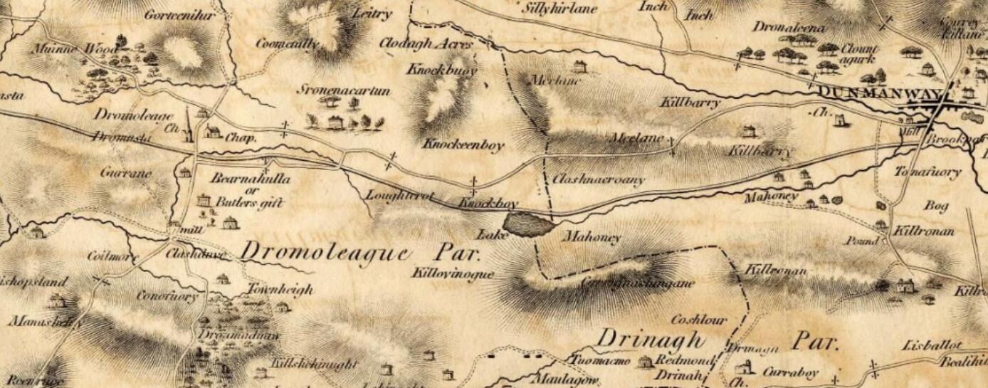
Instead of three lakes, the map shows a single large body of water: Lake Mahoney.
This is a critical observation. By 1811, the road exists — but the lake system has not yet taken on its modern form.
The Mail Coach Road
Further historical references help place this development in context.
In Lewis’s Topographical Dictionary of Ireland, the entry for Bantry describes the “new mail coach road” approaching the town from the south and following the coastline. This aligns with the known route of the improved road network in the early nineteenth century.
Richard S. Harrison, in Four Hundred Years of Drimoleague, also refers in chapter 5 to various road building projects in the district, and to the construction of what he calls the new mail road, dating it to probably 1810 or 1811 based on the GrandJury map of County Cork. However, as mentioned,the Grand Jury Map, according to the Cork City Library is based on surveys taken in the 1790s.
Taken together, these sources suggest that the road through the Three Lakes valley was part of a major infrastructural project around the end of the eighteenth beginning of the nineteenth centuries..
We should bear in mind that at the end of the eighteenth century, Great Britain was fearful of the revolution that had taken place in France, initially that it would foment rebellion in Ireland - which it did in 1798. But also the ensuing war with France means the British government was on alert against any attempt by France at invasion, particularly through Ireland. Especially after Wolfe Tone's threatening move with a French fleet in Bantry Bay in 1796. So was this a mail coach road, or a military necessity?
Engineering the Gorge
Physical evidence on the ground supports the interpretation of these works having a major effect on the landscape and hydrology.
At the eastern end of the lakes, where the road enters Clashnacrona Gorge, there are bare, steep rock faces rising sharply beside the road. (They are well worth looking at - displaying some lovely ripple marks from 350 million years ago). These are not gentle, weathered slopes, but abrupt cuts — strongly suggesting that a substantial volume of rock was removed.
Given the period, this would almost certainly have involved the use of explosives.
The question then arises: where did all that material go?
The most likely answer lies immediately to the west — in the low-lying, waterlogged ground now occupied by the Three Lakes. The construction of a road across this terrain would have required a stable base, almost certainly in the form of a causeway built from imported fill.
It is highly plausible that the excavated rock from the gorge was used to construct this causeway.
From One Lake to Three?
If this interpretation is correct, the implications are significant.
The construction of the road and causeway may have:
- lowered the effective water level within the basin
- altered the natural drainage pathway
- and physically divided a single lake into multiple smaller basins
In other words, Lake O’Mahony may have been transformed into the Three Lakes we see today.
What remains unclear is how this change was managed hydrologically. Lowering a lake level would normally result in increased downstream flow — yet there is, so far, no clear historical record of flooding or increased discharge through Dunmanway.
Was the outflow controlled during construction? Was the transition gradual rather than sudden? At present, we do not know. The first edition Ordnance Survey map does show all three lakes in a slightly different configuration, with islands indicated that are now attached to the shore; but this may be an indication of sedimentation, rather than a change in water level. By this time - the late 1830s / early 1840s - the water level had probably stabilised.
Evidence in the Sediments
This is where palaeoecology becomes crucial.
If the lake level changed significantly in the early nineteenth century, that change should be recorded in the sediments.
Previous coring has already revealed an intriguing clue: a layer of diatomite — indicative of open water conditions — located approximately two metres above the current level of Middle Lake, in sediments between the lake and the road.
This suggests that, at some point in the past, the water level in the basin was substantially higher than it is today.
The key question is whether this higher water level persisted into the historical period — and whether its reduction can be linked to the construction of the road and causeway.
Bringing the Evidence Together
We now have three independent lines of evidence:
- Cartographic — the 1811 map showing a single large lake
- Historical — records of a major road-building project around the same time
- Physical — rock-cutting in the gorge and a causeway across the basin
To these we can add a fourth:
- Stratigraphic — sediment evidence indicating a previously higher lake level
Taken together, these strongly suggest that the modern landscape is, at least in part, the result of early nineteenth-century engineering.
Where This Leads
The next step is to test this hypothesis more rigorously.
High-resolution elevation data from the drone survey will allow the causeway and surrounding terrain to be mapped in detail. Further sediment analysis may reveal whether a distinct change in lake level occurred at the time the road was constructed. This could take the form of dating the sediments above and below the diatomite to see when the algal bloom (if that is what caused the diatomite to be deoposited) occurred; and also detection and analysis of testate amoebae from the peatland nearer the road. Peatland testate amoebae have been found to be directly linked to the depth of water table, though this is principally used in raised bogs. This peatland is not a raised bog.
If confirmed, this would mean that the Three Lakes are not simply a natural post-glacial feature, but a landscape shaped at a critical moment in recent history — where geology, hydrology, and human engineering intersect.
The landscape, it seems, is not just ancient — it is also surprisingly modern.