Tracing Hidden Waters: Uncovering the Past Landscapes of the Three Lakes
Published:April 2025
The landscape history of the Three Lakes site in West Cork provides an opportunity to understand how environments have changed over time. By combining field observations with palaeoecological evidence, it is possible to reconstruct past conditions and trace the development of the landscape.
Reconstructing environmental change in the Three Lakes landscape
Tucked into the hills of West Cork, the Three Lakes site may seem like a quiet corner of Ireland’s natural landscape. But beneath the still surface of Middle Lake, a complex story is buried — one that I am exploring through palaeoecological research using sedimentary ancient DNA (sedaDNA).
My aim is to uncover how biodiversity has changed here since the last glaciation, more than 16,000 years ago. But to understand that ecological history, I first need to understand the landscape itself: how it was formed, how it drains, and why it has remained so relatively undisturbed through millennia of climatic and human change.
Modelling an Elusive Landscape
The first step was to investigate the geomorphology and hydrology of the lake basin using digital mapping tools such as QGIS. I set out to model how water flows into and through the basin — but quickly ran into two key problems.
First, the elevation differences across the basin are extremely subtle. Small variations in the digital elevation model (DEM) caused the drainage network to fragment, making it difficult to produce a coherent flow model.
Second, modern infrastructure — the road and railway that cross the valley — introduced a more fundamental distortion. Both are built on raised causeways, which appear in the model as solid barriers, interrupting natural drainage pathways. In reality, culverts allow water to pass beneath them, but this is not captured in the elevation data.
The result? A broken and unrealistic model that did not reflect how water actually moves through the landscape.
Drainage to the West?
However, when I adjusted the model parameters — allowing more tolerance for subtle elevation changes — a surprising pattern emerged. The drainage system began to cohere, but the basin divided. The eastern lake flowed north east through the gorge as it does today, but the middle and western lakes and their catchments flowed westward, rather than east.
In the image below, the current eastward flow from Three Lakes is shown in yellow; modelled drainage, both westward and eastward, in blue.
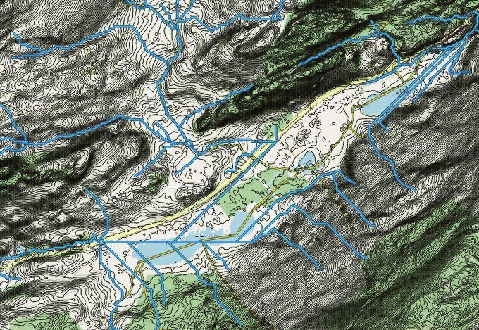
This modelled flow crosses the present watershed, which lies only a metre or two above the basin and just a few hundred metres west from the western lake.
Could the basin once have drained westward?
This possibility gains weight when considering the gorge at Clashnacrona, the present eastern outlet. Both the road and railway appear to have necessitated substantial rock cutting here, suggesting that the gorge may not be entirely natural.
Clues in the Historical Maps
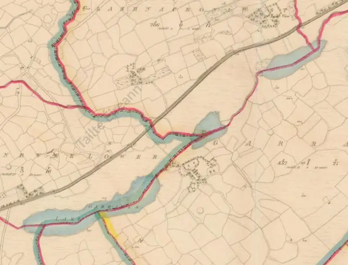
A snapshot of the first edition OS map of Three Lakes. Note the road running through the valley. Click on the image to go to the Tailte Éireann interactive map page.
A snapshot of the 25 inch edition OS map of Three Lakes. Note the railway now runs alongside the road. Click on the image to go to the Tailte Éireann interactive map page.
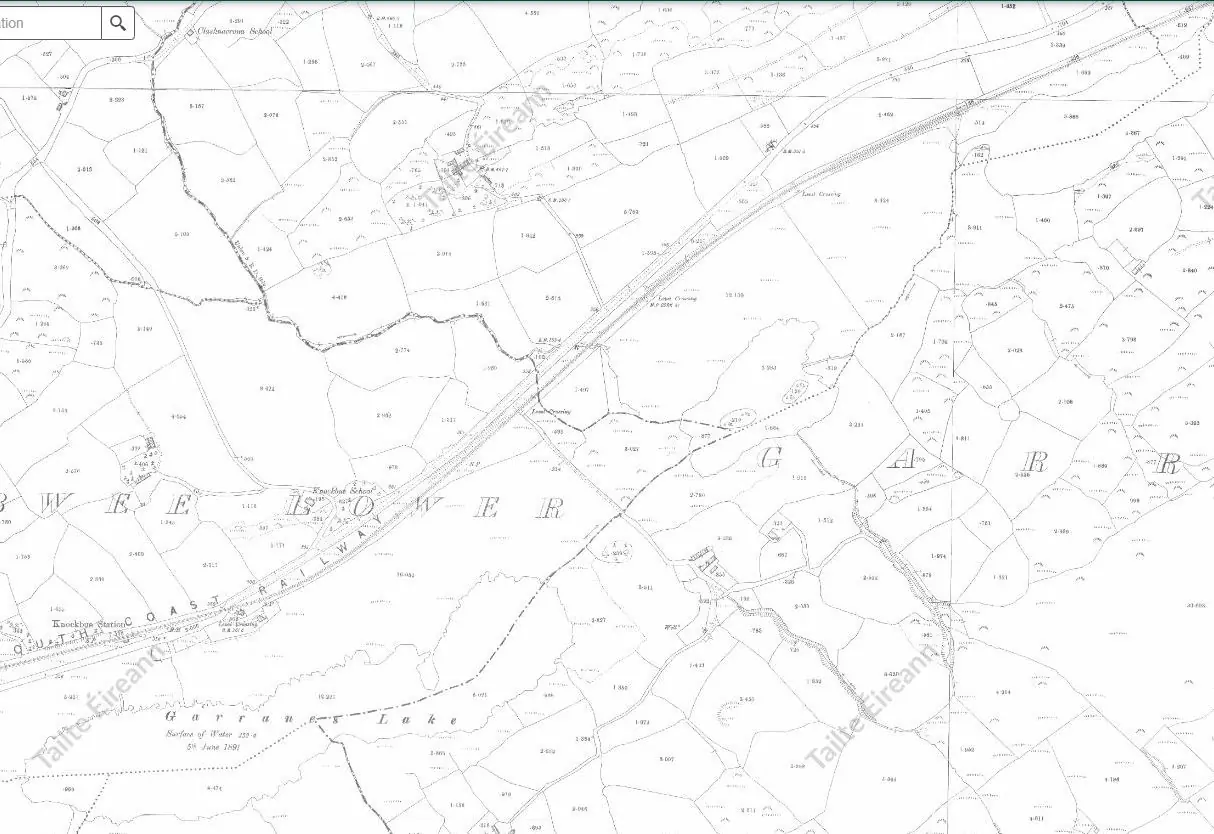
Historical mapping offers further support. I examined early Ordnance Survey maps and found that the railway was built after the first edition survey of the 1830s, and so first appears on the 25 inch map of the 1880s. I know from walking the old railway line that it goes through the gorge at a fairly low level, lower than the current road, and appears to have involved channeling the river in a straight, rock cut channel. That was a start, but I did not find anything more conclusive. That changed when I came across late eighteenth-century route maps.
The Taylor and Skinner maps of 1777 show the principal routes between towns in Ireland. In the south west, the main route from Cork to Bantry — via Dunmanway — is shown. Crucially, it does not pass through the Three Lakes valley.
Instead, it follows a higher route: from Dunmanway along the Kilbarry road and across the north side of the Ruagagh valley, through Drimoleague and Castle Donovan.
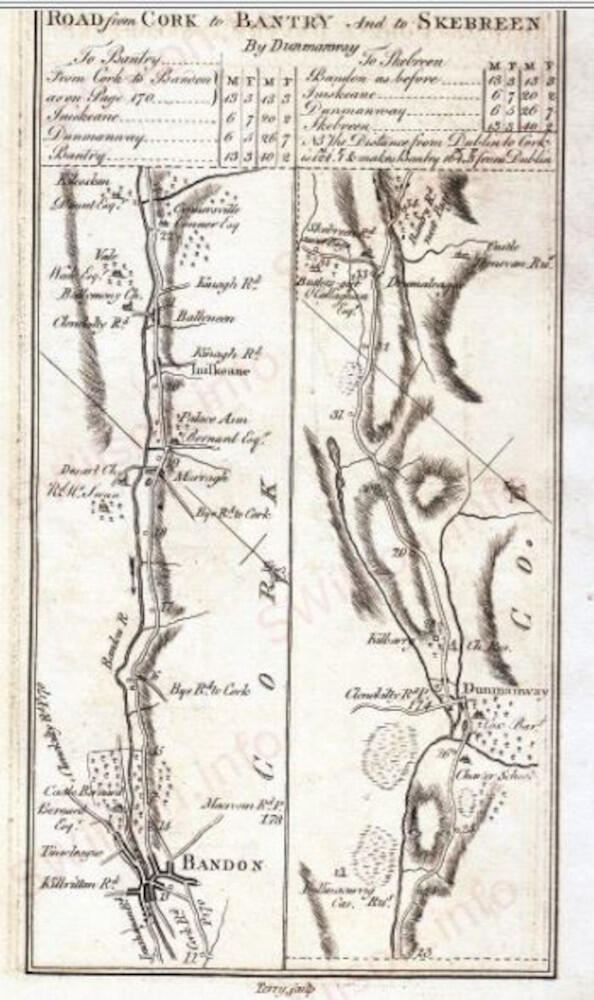
Part of the Taylor & Skinner route map of 1777 showing the main route between Dunmanway and Drimoleague
Parts of this route still exist today, though some sections have been absorbed into private land or have reverted to overgrown farm tracks.
By the time of the first edition Ordnance Survey in the 1830s, the modern road appears — running through the gorge and across a causeway in the wetland. And as I have mentioned, by 1880, the railway is also in place.
Engineering the Landscape
This suggests that the route through the gorge was constructed sometime after 1777 and likely required substantial engineering.
It is possible that this work formed part of wider strategic improvements in the late eighteenth century, perhaps linked to the threat of French-supported rebellion in the 1790s. If so, this route may have been developed as a matter of urgency.
The construction would have involved blasting through rock at the gorge and building a causeway across the wetland. It may also have required partial drainage of the lake system.
These works appear to have significantly altered the landscape — possibly even causing some drainage and dividing a once larger lake into the three smaller lakes we see today.
A Lake Shaped by Ice and Engineering?
Could the Three Lakes valley once have held a much larger body of water — perhaps a proglacial lake formed at the edge of a retreating glacier?
It is certainly plausible. The gorge may once have been blocked by bedrock or moraine, directing water westward. The glaciofluvial sediment mounds in the Ruagagh valley may support this idea. They catch my attention every time I pass — and I hope one day to survey them in detail.
Further clues actually lie in the peatlands near the road. In 2021, after coring the lake, we tried some test corings around the site. At a point about halfway between the middle lake and the road, we discovered diatomite, at about 3.5 metres depth. Diatomite is a deposit of silica of a high degree of purity, being made from the silica frustules (sort of skeletons) of diatoms, a form of algae. It suggests open water existed here. If this represents lake sediment beneath the peat, this would suggest that water once extended far beyond the present lake margins. This needs further investigation - how thick is the diatomite, how extensive, and, most crucially, what period does it date from?
In this way, history, palaeoecology and geomorphology can work together to reconstruct the hidden shape of past landscapes.
What’s Next?
The next step is to improve the resolution of the elevation data. A planned drone survey will provide high-resolution topographic information.
This will allow us to remove modern features such as roads and railways from the digital model and reconstruct a more natural drainage system.
We also need to look more closely at the diatomite.
In delving deeper, we hope to understand how the Three Lakes basin has evolved — how water shaped it, how ice left its mark, and why this place has remained, against the odds, a quiet and undisturbed sanctuary for thousands of years.